
Bangladesh Coast & Marine Territory
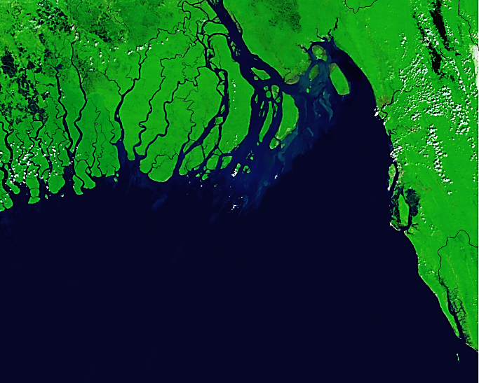
Marine Life Alliance (MLA) works across the full breadth of Bangladesh’s coastline and marine territory—one of the most ecologically rich yet highly threatened regions of the Bay of Bengal. Stretching more than 710 kilometers from the Sundarbans mangrove delta in the west to St. Martin’s Island in the southeast, Bangladesh’s coast supports globally significant species, vital fisheries, unique island ecosystems, and millions of people whose livelihoods are directly linked to the sea. Our work spans this entire landscape, integrating research, conservation, community engagement, and climate resilience to protect both nature and the coastal communities who depend on it.
Bangladesh’s marine and coastal zone includes sandy beaches, coral communities, mudflats, mangroves, estuaries, sea grass beds, offshore waters, and deep channels that host a wide range of marine megafauna. From the vast river mouths of the Western Delta to the high-biodiversity hotspots of Cox’s Bazar, Sonadia, and St. Martin’s Island, these ecosystems provide nesting grounds for sea turtles, feeding grounds for cetaceans and whale sharks, migration corridors for waterbirds, and essential habitats for marine fish and invertebrates. MLA’s efforts focus on protecting these interconnected habitats holistically, addressing threats, supporting local stewardship, and generating scientific knowledge that guides national conservation priorities.
Along the eastern coastline—Cox’s Bazar, Teknaf, Inani, Himchari, and the Maheshkhali Channel—MLA conducts long-term monitoring of sea turtles, corals, cetaceans, whale sharks, seabirds, and coastal vegetation. These areas host critical nesting beaches for olive ridley and green turtles, as well as important feeding and migration areas for Indo-Pacific humpback dolphins, spinner dolphins, bottlenose dolphins, finless porpoises, and Bryde’s whales. St. Martin’s Island, the country’s only coral-bearing island, remains one of our core sites where we monitor reef health, coral bleaching, water quality, and the impacts of tourism and climate change. These habitats are extremely sensitive to erosion, pollution, and overuse, which is why MLA supports habitat restoration initiatives such as screwpine plantation, reef documentation, and community awareness programs.
Sonadia Island—another critical work area—is one of Bangladesh’s most important ecological hotspots, supporting migratory waterbirds, shorebirds, sea turtles, and rich intertidal habitats. MLA works here with fishers and local residents to reduce bycatch, restore shoreline vegetation, remove harmful plastic and ghost nets, and monitor changes in wildlife populations. This area is under significant pressure from fishing, unplanned tourism, and habitat loss; therefore, our long-term presence provides essential ecological data and community-based solutions.
Further west toward the Sundarbans—the world’s largest mangrove forest and a UNESCO World Heritage Site—MLA engages in marine species reporting, awareness-building, and collaborative monitoring. The Sundarbans and adjacent waters support Irrawaddy dolphins, finless porpoises, many species of sharks and rays, and a high diversity of riverine and coastal birds. Our efforts contribute to ongoing national and international conservation initiatives, linking local observations to broader regional research. Although the ecosystem is more riverine and estuarine compared to the sandy eastern beaches, it remains a key part of Bangladesh’s marine territory and an important area for MLA’s wider conservation framework.
MLA’s offshore work extends into the Exclusive Economic Zone (EEZ) of Bangladesh, where we document sightings of whale sharks, dolphins, whales, and pelagic fish species. As Bangladesh expands its blue economy initiatives, sustainable management of these offshore habitats is becoming increasingly important. Our work in these waters includes supporting the development of national databases, collaborating with fishers on safe-release protocols, and promoting responsible fisheries practices that reduce mortality of protected species.
Across the entire coastline, MLA focuses strongly on community engagement. Coastal communities—including fishers, youth groups, women’s networks, boat operators, and local leaders—are central partners in our conservation efforts. We provide training on bycatch reduction, safe release of entangled animals, waste management, alternative livelihood opportunities, and environmentally responsible tourism practices. By strengthening local knowledge and participation, we help ensure that conservation efforts are meaningful, long-lasting, and community-owned.
Climate change continues to reshape Bangladesh’s coastline, increasing erosion, sea-level rise, cyclones, and salinity. MLA addresses these urgent challenges through nature-based solutions such as dune stabilization, native vegetation restoration, and screwpine plantation to protect vulnerable beaches, reduce storm impacts, and maintain natural habitats for wildlife. These efforts help build resilience not only for ecosystems but also for local communities whose homes, resources, and safety depend on a healthy coastline. Throughout all regions, MLA invests in data-driven conservation. Our teams use GPS mapping, drone surveys, photographic identification, community reporting networks, and ecological assessments to track changes in species populations and habitat conditions. These data are shared with government agencies, research institutions, and conservation networks to support policy development and national planning. By working across the entire coast and marine territory of Bangladesh, Marine Life Alliance remains committed to protecting biodiversity, sustaining coastal communities, and building a resilient future for one of the most biologically rich and socially important marine regions in the world.
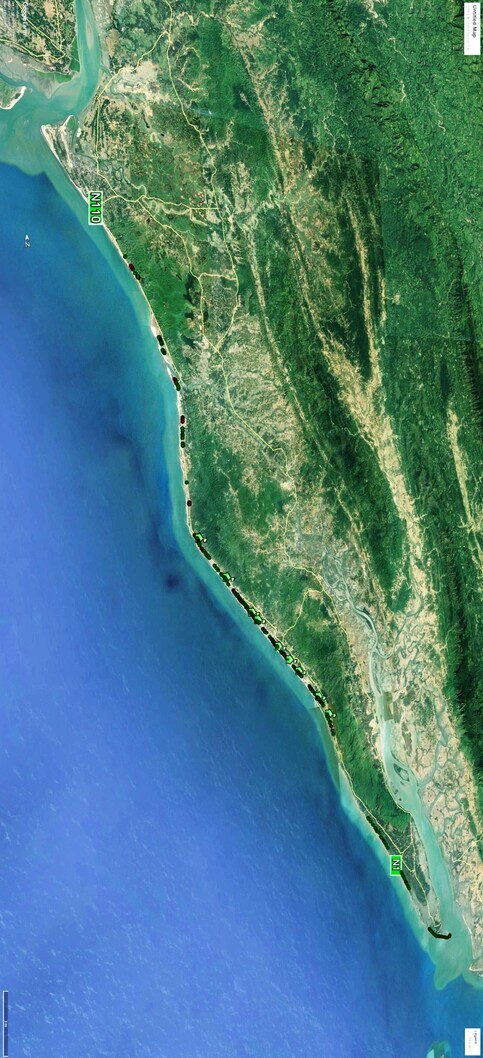
Cox’s Bazar - Shahporir Dwip
Our coastal work area stretches across one of the most ecologically rich and socially dynamic regions of Bangladesh—the coastline from Cox’s Bazar to Shahparir Dwip. This extensive coastal belt, positioned along the eastern edge of the Bay of Bengal, contains a mosaic of sandy beaches, estuaries, mangroves, dunes, tidal flats, islands, and nearshore waters that support an exceptional diversity of marine life. It is also home to thousands of people whose livelihoods depend directly on the health of these ecosystems. Our programs in this region aim to protect its fragile biodiversity while uplifting the communities who live closest to the sea.
Cox’s Bazar, known for having the longest natural sandy beach in the world, is a critical nesting ground for marine turtles, especially the Green Turtle and Olive Ridley. The uninterrupted stretch of beaches, combined with key offshore feeding habitats, makes this coastline one of the most important sea turtle conservation zones in the northern Bay of Bengal. Our work here involves long-term nesting monitoring, reducing bycatch through fishers’ collaboration, habitat protection, and raising awareness among coastal communities. Beyond turtles, Cox’s Bazar waters support resident and migratory cetaceans—dolphins and whales that rely on the shallow and deep-water gradients of the region. This area is also a transit zone for whale sharks, making it essential for recording sightings, identifying threats, and working with fishers to prevent accidental harm.
Moving southward, the Teknaf Peninsula and the surrounding coastal waters host dolphins, porpoises, seabirds, and numerous threatened fish species. The estuarine and nearshore waters near Teknaf are some of the most productive in the region, supporting artisanal fishers and providing critical foraging grounds for marine megafauna. Along this stretch, we work closely with fishing communities to reduce bycatch, promote safer fishing practices, and build awareness about marine conservation. The coastal dunes and vegetation belts, including screwpine plantations, play an important role in buffering villages from storm surges, and our restoration efforts directly contribute to strengthening this natural defense.
Shahparir Dwip, located at the southernmost tip of Bangladesh, is one of our most sensitive and high-priority work areas. The island faces intense environmental pressure—from strong currents, erosion, and storms to fishing pressure and the impacts of climate change. Despite these challenges, Shahparir Dwip remains a vital zone for migratory seabirds, marine turtles, and several dolphin species. The sandy beaches and tidal flats provide key feeding and resting sites for waterbirds, while the surrounding sea supports dolphins and, occasionally, whale sharks. Our team conducts regular wildlife monitoring, engages fishers in reporting sightings, supports habitat restoration, and raises awareness about the importance of protecting this unique marine environment. Across the entire region—from Cox’s Bazar town, Inani, Himchari, Teknaf, to Shahparir Dwip—we integrate community-based conservation with scientific research. We work with local youth, volunteers, fishers, school groups, and authorities to build a culture of marine stewardship. Our efforts include coral health monitoring expeditions, removal of ghost nets and marine debris, beach clean-ups, protection of nesting sites, and training programs that help coastal communities adopt sustainable practices. At the same time, we apply GIS mapping, species databases, and long-term ecological surveys to support evidence-based decision-making and conservation planning.
This coastal belt is a place where wildlife, ecosystems, and people are deeply interconnected. By focusing our work across this region, we aim to protect marine biodiversity, strengthen ecosystem resilience, and support the well-being of communities living along the frontline of climate change and environmental challenges. Through long-term commitment, strong partnerships, and continuous field presence, we strive to safeguard this extraordinary coastline for future generations.